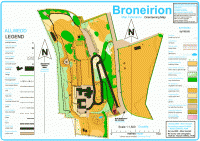
Broneirion
Broneirion is a small residence with adjacent gardens that is owned by the Girl Guide Association. It is made up of a country house with small terraced grassed areas, garden buildings, car parking area and small areas of trees many of which are individually mapped. There is an adjacent flat open field that is used for camping across a country lane from the main Broneirion site that we are also using. Ordinarily Broneirion is not suitable for a regular orienteering event due to its small size but using the area at night adds to the challenge.
Map is 1:1500 (yes 1cm on the map equals 15metres on the ground approximately). Magnetic north correct as of 2009. Map surveyed 2009 to 2011 by Robert Griffiths.
Location
Nearest town: Llandinam
- Grid Ref: SO022886
- Postcode: SY17 5DD
- Latitude: 52.48854
- Longitude: -3.44294
- Google Map (aerial) - Bing Map (OS)
Last edited: 01st Jan 12
