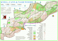
Nash Woods
The area is very popular with walkers, horse riders, mountain bikers and runners. But most of these use the main forestry tracks and some of the larger pathways, the rest of the forest is rarely accessed.
The area has been used for major League events and provides challenges to most technical abilities, testing your navigational skills as well as your map reading skills.
The terrain is mainly wooded with conifer and deciduous trees situated on a hill which runs the length of the area, with steep sections in places. The ridge of the hill runs west to east with the north side in Wales and the south side in England. The conifer areas are covered in brashings (small cut branches), which makes running difficult; the deciduous areas have varying degrees of undergrowth. The area has a number of forestry tracks and numerous paths some indistinct.
The map has been updated several times to accommodate changes after felling operations in different parts of the forest. The latest version was updated in 2018 and is now georeferenced, further small changes have been made the last being on 26th September 2021.
Location
Nearest town: Presteigne
- Grid Ref: SO314643
- Postcode:
- Latitude: 52.27203
- Longitude: -3.00516
- Google Map (aerial) - Bing Map (OS)
Last edited: 01st Jan 12
