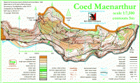
Coed Maenarthur October 2013

Date of event: Sun 20th Oct 2013
Level of event: Local (D)
Nearest town: Pontrhydygroes
Results
Terrain is varied but mainly steep wooded hillside with a few gentle wooded slopes, some moderate undergrowth in parts so full leg cover is compulsory. Take care for steep crags across the area. Orange and Yellow courses do not encounter these but please be aware anyway. Whistles should be carried. Cagoules may be deemed compulsory in adverse weather conditions.
Location:
- Nearest town: Pontrhydygroes
- Grid Ref: SN 734729
- Postcode:
- Latitude: 52.33979
- Longitude: -3.85932
- Google Map (aerial) - Bing Map (OS)
Officials:
- Planner: Megan Carter-Davies
- Organiser: Megan Carter-Davies
- Controller:
Info for dog owners
Dogs are allowed on site, please keep on a lead.
Facilities
There are no facilities available on site.
About the area/map
Coed Maenarthur
Steep Forestry Commission woodland with crags and contour features in abundance, approximately 2000 meters long by 800 meters wide. Bordered on its southern area by a river which runs along ite entire length.
Read more about the Coed Maenarthur area and map
Please note: when entering our events your name may appear in the results section of this website or in newspaper reports.
Read our privacy policy to see how we look after your personal data.
Posted by Terry Smith
