Coed Maenarthur

Date of event: Sun 29th Mar 2015
Level of event: Local (D)
Nearest town: Devils Bridge
Results
This attractive woodland is on the north side of the Ystwyth river and is best accessed from either New Row from the west, or Pontrhydygroes from the south and the east.
Courses have been designed to keep away from the road but competitors will need to cross it in several places and there may be some runners. Please show consideration to other users; Maenarthur is also used by walkers and the occasional mountain biker.
Although courses have been generally planned to avoid the worst of the brambles, this has not been entirely possible for some of the routes on the longer courses.
There will be cakes available afterwards, with all proceeds to squad funds.
Location:
- Nearest town: Devils Bridge
- Grid Ref: SN 736729
- Postcode: SY25 6DS
- Latitude: 52.33588
- Longitude: -3.85721
- Google Map (aerial) - Bing Map (OS)
Officials:
- Planner: Garson Family
- Organiser: Garson Family
- Controller: Garson Family
Info for dog owners
Allowed under control
Facilities
No facilities available
About the area/map
Coed Maenarthur
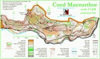
Steep Forestry Commission woodland with crags and contour features in abundance, approximately 2000 meters long by 800 meters wide. Bordered on its southern area by a river which runs along ite entire length.
Read more about the Coed Maenarthur area and map
Please note: when entering our events your name may appear in the results section of this website or in newspaper reports.
Read our privacy policy to see how we look after your personal data.
Posted by Terry Smith
