Nash Woods 2017
Date of event: Sun 19th Feb 2017
Level of event: District (C)
Nearest town: Presteigne
Results
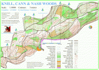
The terrain is mainly wooded with conifer and deciduous trees situated on a hill which runs the length of the area, with steep sections in places. The ridge of the hill runs west to east with the north side in Wales and the south side in England. The conifer areas are covered in brashings (small cut branches), which makes running difficult; the deciduous areas have varying degrees of undergrowth. The area has a number of forestry tracks and numerous paths some indistinct.
Runners need to be aware that the area is popular with other users, walkers with dogs, horse riders and mountain bikers so when crossing tracks or paths please take care.
Location:
- Nearest town: Presteigne
- Grid Ref:
- Postcode:
- Latitude: 52.26588
- Longitude: -3.00630
- Google Map (aerial) - Bing Map (OS)
Officials:
- Planner: Terry Smith
- Organiser: Terry Smith
- Controller: TBA
Info for dog owners
Dogs are permitted but must be kept under control, any fouling must be picked up and disposed of in the appropriate bin.
Facilities
There will a portable toilet available near registration otherwise there are toilets at the leisure centre, which is opposite to school car park.
The local Scout Group will be providing refreshments of hot and cold drinks, cakes and hopefully sausage and burgers.
Image Gallery
Click the image for a larger version.
About the area/map
Nash Woods
The area is very popular with walkers, horse riders, mountain bikers and runners. But most of these use the main forestry tracks and some of the larger pathways, the rest of the forest is rarely accessed.
The area has been used for major League events and provides challenges to most technical abilities, testing your navigational skills as well as your map reading skills.
The terrain is mainly wooded with conifer and deciduous trees situated on a hill which runs the length of the area, with steep sections in places. The ridge of the hill runs west to east with the north side in Wales and the south side in England. The conifer areas are covered in brashings (small cut branches), which makes running difficult; the deciduous areas have varying degrees of undergrowth. The area has a number of forestry tracks and numerous paths some indistinct.
The map has been updated several times to accommodate changes after felling operations in different parts of the forest. The latest version was updated in 2018 and is now georeferenced, further small changes have been made the last being on 26th September 2021.
Read more about the Nash Woods area and map
Please note: when entering our events your name may appear in the results section of this website or in newspaper reports.
Read our privacy policy to see how we look after your personal data.
Posted by Terry Smith


